Chart work is one of the most scoring yet concept-heavy subjects in the Second Mate (FG) examinations. Many candidates struggle not because the syllabus is vast, but because chartwork questions combine multiple navigation concepts in a single problem. This guide breaks chartwork down into clear, exam-oriented logic, helping you understand what gives a Position Line (PL), what gives a Position Circle (PC), and how examiners expect you to plot answers.
Snippet
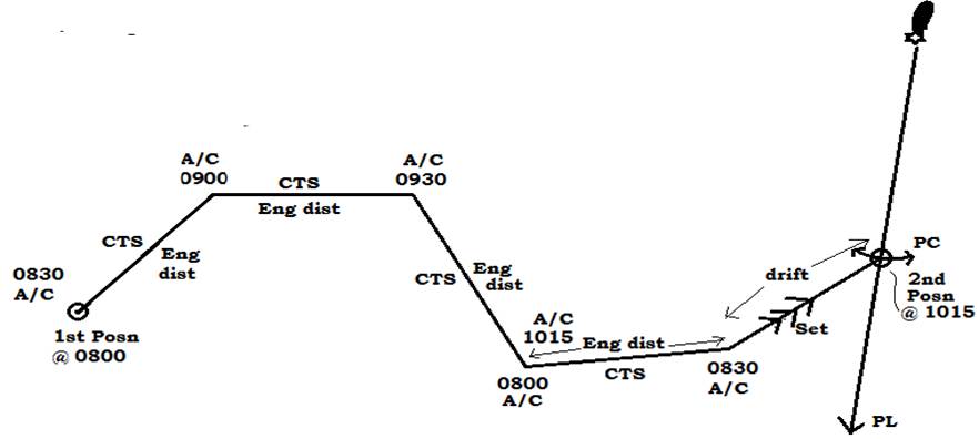
Chart work for Second Mates involves plotting a ship’s position, course, speed, current, and observations on a nautical chart using position lines (PL) and position circles (PC). It includes HSA, bearings, distance off, current triangles, transfer of position, and three-point bearings, tested heavily in written and oral exams.
CHARTWORK
What Is Chart Work in the Second Mate Exam?
Chart work numericals are combinations of navigation concepts, not isolated problems. A single question may involve:
- Bearings + current
- HSA + transfer of position
- Distance off + time to go
Your first task in every question is to identify what observation gives a PL and what gives a PC.
Chartwork numericals are a combination of one or more concepts.So it is necessary to understand these concepts.
Position Line (PL) means ship is anywhere on this line.
Position circle (PC) means ship is anywhere on this circle.
Position fix can be obtained by
- Intersection of 2 or more such PL or PC at the same time.
- Lat/long
- Position can be given by chart datum depth on chart, e.g. 9m.
Before We Start: Concept of VSA and HSA
Sextant angles are used to determine a ship’s position without depending on GPS or compass accuracy.
There are two important types of sextant angles:
- Vertical Sextant Angle (VSA)
- Horizontal Sextant Angle (HSA)
Part 1: Vertical Sextant Angle (VSA)
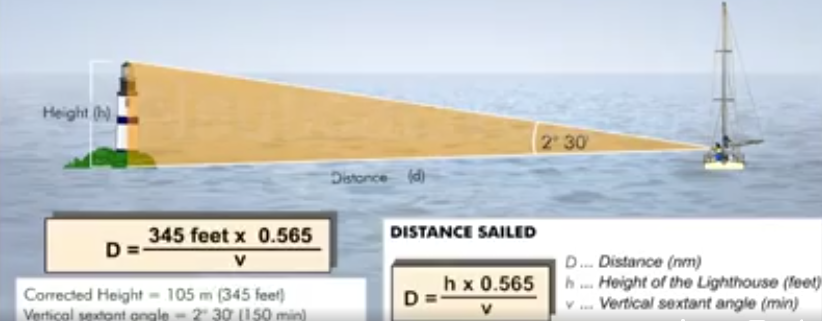
Goal
To find the distance off from a single visible landmark.
Use Cases
- When only one lighthouse or peak is visible
- To verify radar distance or maintain safe distance from shore
- To remain clear of shallow water near cliffs using vertical danger angle
Simple Explanation
Imagine a lighthouse as a tall pole standing on the shore.
Using a sextant, you measure how tall that pole appears to your eye.
If the object looks tall, you are close.
If the object looks small, you are far.
Because the height of the lighthouse is known and the angle is measured, your distance from it can be calculated.
Information Required
From the Nautical Chart
Height of the object in metres.
Example: “Fl 10s 45m” means the height is 45 metres above Mean High Water Springs.
From the Sextant
Vertical angle measured by holding the sextant vertically and bringing the top of the object down to the waterline.
Calculation Method
- Distance in nautical miles equals: (h * 1.854) NM
Height in metres multiplied by 1.854,
Why 1.854?
It converts metres and minutes of arc into nautical miles
2. Divide by the angle obtained from sextant in minutes.
.
Example
- Charted height: 60 metres
- Measured angle: 42 minutes
Calculation:
- 60 × 1.854 = 111.24
- 111.24 ÷ 42 = 2.65 nautical miles
Result
Draw a circle on the chart centered on the lighthouse with a radius of 2.65 nautical miles.
Your ship lies somewhere on this circle.
Part 2: Horizontal Sextant Angle (HSA)
Goal
To find a circular position line using two landmarks without using a compass.
Use Cases
- Accurate position fixing without compass error
- Hydrographic surveying
- Avoiding underwater dangers using horizontal danger angle
Simple Explanation
The angle between two objects on land changes as the ship moves.
For any given angle, there is only one possible circle on the chart passing through both objects and the ship.
By measuring this angle, the ship’s position lies on that circle.
Information Required
From the Chart
Two clearly identifiable landmarks.
From the Sextant
Horizontal angle measured by holding the sextant horizontally and aligning one object over the other.
Base Angle Concept
The centre of the position circle is found using the base angle.
Base angle equals:
90 degrees minus the measured horizontal sextant angle.
Plotting Steps
- Measure the horizontal sextant angle
- Subtract the angle from 90 degrees to get the base angle
- Join both landmarks with a straight line
- From each landmark, draw the base angle towards the sea
- The intersection of these lines is the centre of the circle
Result
Using the centre point, draw a circle passing through the landmarks.
Your ship lies somewhere on this circular position line.
To obtain a fix, repeat the process with a third object.