Basics of Chart Work – Terrestrial Navigation 1
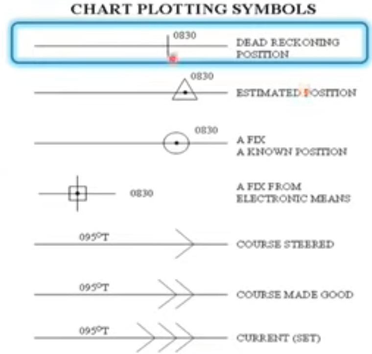
Chartwork is the foundation of traditional marine navigation. Even in the age of GPS, every deck officer must understand how to plot a ship’s position using symbols like Dead Reckoning (DR), Estimated Position (EP), Fix, Course Steered, Course Made Good (CMG), and Current (Set & Drift). These symbols help you track where the vessel should be, where it actually is, and how wind or current is affecting its movement.
| Symbol | Meaning | Description |
|---|---|---|
| Horizontal line with vertical tick + time (e.g., 0830) | Dead Reckoning Position (DR) | A predicted position based on course and speed over time, without external fixes. Used when no fix is available. |
| Triangle + time | Estimated Position (EP) | A position based on dead reckoning plus additional information (like wind, current), but still not confirmed by a fix. |
| Circle with dot + time | Fix (Known Position) | A confirmed position determined by visual bearings or celestial observations. Most reliable. |
| Square with crosshairs + time | Electronic Fix | A position obtained using electronic navigation systems like GPS, radar, or echo sounder. |
| Single arrow + direction (e.g., 095°T) | Course Steered | The direction the vessel is intended to travel through the water, based on compass heading. |
| Double arrow + direction | Course Made Good | The actual direction traveled over ground, considering effects like wind and current. |
| Triple arrow + direction | Current (Set) | The direction in which the water is moving, affecting the vessel’s movement over ground. |
Dead reckoning position (DR)
Symbol: Straight line track with a short vertical tick and time (e.g., 0830).
Meaning: A DR position is where you predict the ship to be based only on:
- Last known position
- Course steered
- Speed through water
- Time run
No allowance for wind, current, steering error, or leeway is made, so it’s approximate.
Example (practical):
- At 0800 your fix is: 20∘00′N,088∘00′E.
- You steer course 090∘T at 10 knots.
- After 30 minutes (0.5 hours), DR distance = 10×0.5=5 nautical miles.
- On the chart, you measure 5 NM along 090°T from the 0800 position.
- That point is marked with the DR symbol and time “0830”.
This is your theoretical position if nothing else (wind/current) acted on the vessel.
Estimated position (EP)
Symbol: Triangle with time.
Meaning: EP is a refined DR that includes your best estimate of errors due to:
- Wind
- Current (set and drift)
- Leeway
- Helm/steering error
But it’s still not a true fix – it’s your best guess, adjusted using whatever info you have.
Example:
- From DR, at 0830 you should be 5 NM due east of your 0800 fix.
- You know there is a current setting 180∘T at 2 knots.
- In 0.5 hours, current carries you 1 NM south.
- On the chart:
- Plot DR position (5 NM east).
- From that DR point, plot 1 NM south for current.
- Mark that resulting position with a triangle and “0830”.
That triangle is the EP – more realistic than DR, but not confirmed.
Fix (known position)
Symbol: Circle with a dot in the center + time.
Meaning: A fix is a position determined from actual observations, not just calculations. Traditionally:
- Intersection of 2–3 visual bearings to shore objects (lighthouse, tower, buoy).
- Or celestial observations (sun, stars) reduced to lines of position.
It’s considered a reliable, known position (more reliable than DR or EP).
Example:
- At about 0830, you take bearings:
- Lighthouse A: 045°T
- Buoy B: 120°T
- You plot both lines of position on the chart.
- Where they cross is your fix.
- Mark it with the circle-and-dot symbol and write “0832”.
This is your actual position at that time.
Electronic fix
Symbol: Square with crosshairs + time.
Meaning: A fix obtained from electronic means like:
- GPS/GNSS
- Radar ranges and bearings
- Echo sounder cross-checks with contour lines
- Loran/Decca (historically)
Electronic fixes are usually very accurate but must be checked against chart datum and system errors.
Example:
- GPS at 0830 gives: 20∘00.5′N,088∘05.2′E.
- You plot that point directly on the chart.
- Mark it with a square-with-crosshairs symbol and write “0830”.
If you also have a visual fix nearby, you might compare them to see if GPS/chart are aligned correctly.
Course steered
Symbol: Single arrow along your intended track, marked “095°T”.
Meaning: This is the direction you’re steering through the water, based on your compass/gyro.
- Expressed in degrees True on the chart (hence “T”).
- It’s the intended or ordered course – what the helmsman is holding.
Example:
- Master orders: “Steer 095°”.
- You convert from compass/gyro to True and get 095°T.
- On the chart, from your last fix (0800), draw a line in direction 095°T.
- Mark it with a single arrow and label “Cst 095°T”.
That line is your planned track through the water, not necessarily what you actually make over ground.
Course made good (CMG)
Symbol: Double arrow along the actual track, marked “095°T” (or whatever the result is).
Meaning: CMG is the actual direction over the ground between two known positions (usually fixes).
- It includes all effects of current, wind, leeway, steering errors, etc.
- Calculated from the line joining the earlier fix to the later fix.
Example:
- Fix at 0800.
- Next fix at 0830 (from GPS or visual).
- Draw a straight line from 0800 fix to 0830 fix.
- Measure the bearing of that line: suppose it’s 100°T, not 095°T.
- Mark that line with a double arrow and label “CMG 100°T”.
You see that although you steered 095°T, the ship actually traveled along 100°T due to current/wind.
Current (set)
Symbol: Triple arrow showing direction, marked “095°T” (or whatever the set is).
Meaning: In plotting, the triple arrow represents current:
- Set: Direction the water is flowing (in degrees True).
- Drift: Speed of current (in knots) – usually written nearby.
Together, they explain the difference between course steered and course made good.
Example (linking all three):
- At 0800: Fix at point A.
- Course steered: 095°T at 10 knots.
- At 0830: Fix at point B.
- You find:
- Distance from A to DR position (based on 095°T, 10 knots, 0.5 h) is 5 NM.
- Actual fix at 0830 is, say, 1.5 NM south of the DR position.
- You plot a vector from DR position to actual fix:
- Direction of that arrow = set of current, say 180°T.
- Length represents drift, e.g., 3 knots (over 0.5 h gives 1.5 NM).
You draw that as a triple-arrow vector from DR to fix and label “Set 180°T, Drift 3 kn”.
How they all work together in one scenario
Imagine you are teaching this in class:
- 0800 fix: Mark with circle-and-dot.
- Course steered: Draw a line 095°T, 10 knots. Mark single arrow.
- 0830 DR: 5 NM along that line → DR symbol with “0830”.
- Current known from tide tables: Set 180°T, 3 knots.
- EP at 0830: From DR, 1.5 NM south (due to current) → triangle, “0830”.
- Electronic fix at 0831 via GPS: Slightly different again → square with crosshairs, “0831”.
- CMG: Connect 0800 fix and 0831 electronic fix, bearing maybe 098°T → double arrow.
- Current vector: Triple arrow from DR to actual fix showing the set/drift.
This is the classic vector triangle: Course steered + current = course made good.
🧭 Exercise Set 1: DR, EP, Fix, CMG & Current (Beginner Level)
Exercise 1 — Basic DR & Fix
Given:
- 0800 Fix: 20∘00.0′N, 088∘00.0′E
- Course steered: 090°T
- Speed: 10 knots
- Next visual fix at 0830 from bearings:
- Lighthouse A: 045°T
- Buoy B: 120°T
Tasks:
- Plot the 0800 fix.
- From the fix, draw the course steered 090°T.
- Calculate DR distance for 30 minutes and plot 0830 DR.
- Plot the 0830 fix using the two bearings.
- Draw the CMG between 0800 and 0830 fixes.
- Compare DR vs Fix and comment on possible current.
🧭 Exercise 2 — DR, EP & Known Current
Given:
- 1000 Fix: 19∘50.0′N, 087∘40.0′E
- Course steered: 135°T
- Speed: 12 knots
- Known tidal current:
- Set: 090°T
- Drift: 2 knots
- Time of EP: 1030
Tasks:
- Plot the 1000 fix.
- Plot DR for 30 minutes (distance = 6 NM).
- From the DR point, apply current vector (1 NM east).
- Mark the resulting point as EP 1030.
- Label all vectors clearly.
🧭 Exercise 3 — DR, EP, Electronic Fix & Current Vector
Given:
- 1200 Fix: 18∘40.0′N, 087∘20.0′E
- Course steered: 210°T
- Speed: 8 knots
- Known wind causing 2° leeway to port
- GPS electronic fix at 1230: 18∘35.5′N, 087∘18.0′E
Tasks:
- Plot the 1200 fix.
- Apply leeway: new course steered = 208°T.
- Plot DR for 30 minutes (distance = 4 NM).
- Apply estimated wind/current to get EP.
- Plot the 1230 electronic fix.
- Draw CMG between 1200 and 1230 fixes.
- From DR to Fix, draw the current vector (triple arrow).
- Label set & drift.
🧭 Exercise 4 — Full Vector Triangle (Advanced)
Given:
- 1400 Fix: 18∘10.0′N, 087∘00.0′E
- Course steered: 300°T
- Speed: 14 knots
- At 1430, radar ranges give a fix at: 18∘13.0′N, 086∘58.0′E
Tasks:
- Plot the 1400 fix.
- Plot DR for 30 minutes (distance = 7 NM).
- Plot the 1430 radar fix.
- Draw CMG between 1400 and 1430 fixes.
- From DR to Fix, plot the current vector.
- Determine:
- Set (direction of current)
- Drift (speed of current)
- Label all symbols correctly.
🧭 Exercise 5 — Mixed Fixes & Error Analysis
Given:
- 1600 GPS fix: 17∘50.0′N, 086∘40.0′E
- Course steered: 045°T
- Speed: 9 knots
- Visual fix at 1630 from:
- Beacon X: 300°T
- Tower Y: 020°T
- Known current from tide tables:
- Set: 180°T
- Drift: 1.5 knots
Tasks:
- Plot the 1600 electronic fix.
- Plot DR for 30 minutes (distance = 4.5 NM).
- Apply current to get EP 1630.
- Plot the 1630 visual fix.
- Compare EP vs Fix and comment on:
- Accuracy of tide table current
- Steering error
- Possible gyro error