Understanding the GMDSS Sea Areas
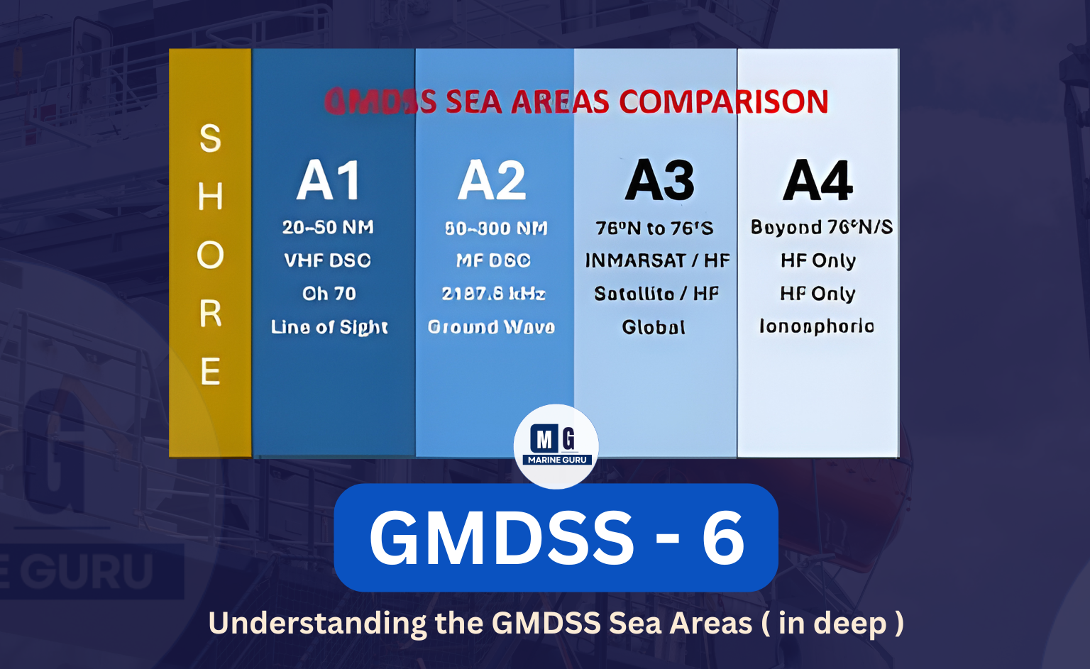
GMDSS divides the oceans into four distinct communication zones, based on radio coverage and available coast station services.
Each zone defines what radio equipment must be carried on board.
Sea Area A1 — VHF Coverage Zone
Definition:
Within range of at least one VHF coast radio station, where continuous DSC watch on Channel 70 (156.525 MHz) is available.
Typical Range: 20–50 nautical miles (depending on antenna height).
Required Equipment:
| Equipment | Mode | Frequency / Channel | Purpose |
|---|---|---|---|
| VHF DSC | DSC | Channel 70 | Digital distress and routine alerts |
| VHF Radiotelephony | Voice | Channel 16 | Distress, safety & routine voice calls |
| NAVTEX | NBDP | 518 kHz | Coastal MSI (Maritime Safety Information) |
| EGC | Data | If not covered by NAVTEX | Satellite MSI via Inmarsat |
| INMARSAT-C | Data | (If carried) | Global communication backup |
| EPIRB (COSPAS–SARSAT) | Satellite beacon | 406 MHz | Secondary automatic distress alert |
Practical Example:
A ship 30 NM off Mumbai coast can easily reach the coast station using VHF DSC Channel 70 for alerting, and then switch to Channel 16 for voice.
NAVTEX (518 kHz) provides daily navigational and weather warnings.
Memory Tip:
“A1 = Always on VHF.”
Sea Area A2 — MF Coverage Zone
Definition:
Outside A1, but within range of at least one MF coast station with continuous DSC watch at 2187.5 kHz.
Typical Range: 50–150 NM
Required Equipment:
| Equipment | Mode | Frequency / Channel |
|---|---|---|
| VHF DSC | DSC | Ch 70 |
| MF DSC | DSC | 2187.5 kHz |
| VHF Radiotelephony | Voice | Ch 16 |
| NAVTEX | NBDP | 518 kHz |
| EGC | Data | If NAVTEX not available |
| INMARSAT-C | Data | If fitted |
| EPIRB (COSPAS–SARSAT) | Satellite | 406 MHz |
Practical Example:
A coastal vessel 120 NM offshore sends a DSC distress on 2187.5 kHz, received by the MF coast station. If the ship also carries Inmarsat-C, the same alert is automatically transmitted as backup.
Memory Tip:
“A2 = MF for Medium Far.”
Sea Area A3 — HF & Satellite Coverage
Definition:
Outside A1 and A2, but within the coverage of an Inmarsat geostationary satellite (between latitudes 76°N and 76°S).
Required Equipment:
| Equipment | Mode | Frequency / Channel |
|---|---|---|
| VHF DSC | DSC | Ch 70 |
| VHF Radiotelephony | Voice | Ch 16 |
| MF DSC | DSC | 2187.5 kHz |
| HF DSC | DSC | 8414.5 kHz and at least one more HF DSC frequency |
| INMARSAT-C | Data | Fleet 77 / Inmarsat-C terminal |
| NAVTEX | NBDP | 518 kHz (if available) |
| EGC | Data | SafetyNET messages |
| EPIRB (COSPAS–SARSAT) | Satellite | 406 MHz |
Example:
A ship in mid-Atlantic transmits distress through Inmarsat-C (Space Wave propagation) to the Rescue Coordination Centre. HF DSC (8414.5 kHz) acts as backup.
Memory Tip:
“A3 = Inmarsat Sky Zone.”
Sea Area A4 — Polar & High-Latitude Regions
Definition:
Beyond A3 — typically north of 76°N or south of 76°S — where Inmarsat coverage is unavailable.
Required Equipment:
| Equipment | Mode | Frequency / Channel |
|---|---|---|
| VHF DSC | DSC | Ch 70 |
| MF DSC | DSC | 2187.5 kHz |
| HF DSC | DSC | 8414.5 kHz + all other HF DSC frequencies |
| NAVTEX | NBDP | 518 kHz (if available) |
| EPIRB (COSPAS–SARSAT) | Satellite | 406 MHz |
| EGC / HF NBDP | Data | SafetyNET (where available) |
Example:
A ship operating near the Antarctic transmits a distress alert via HF DSC (8414.5 kHz), and the EPIRB automatically relays the same to COSPAS–SARSAT satellites.
Memory Tip:
“A4 = Arctic Alerts Always on HF.”
Watchkeeping Requirements
Ships must maintain a continuous watch on the appropriate distress frequencies, depending on their sea area.
| Sea Area | DSC Channel(s) | Voice Channel | MSI System | Satellite |
|---|---|---|---|---|
| A1 | VHF Ch 70 | VHF Ch 16 | NAVTEX 518 kHz | Inmarsat (if fitted) |
| A2 | VHF Ch 70, MF DSC 2187.5 kHz | VHF Ch 16 | NAVTEX / EGC | Inmarsat (if fitted) |
| A3 | VHF Ch 70, MF & HF DSC | VHF Ch 16 | NAVTEX / EGC | Inmarsat |
| A4 | VHF, MF, HF DSC | VHF Ch 16 | NAVTEX (if available) | COSPAS–SARSAT |
Remember:
“Watchkeeping never sleeps — VHF always listens.”
Passenger Ship Additional Requirements
Passenger ships have extra safety layers under GMDSS.
- Distress Panel (Remotely controlled) —
Installed on the bridge, allowing quick distress transmission via VHF, MF/HF, and Inmarsat terminals. - Automatic Position Updating —
All relevant GMDSS systems (like DSC and Inmarsat) must update position automatically from the ship’s GPS. - VHF RT on 121.5 MHz and 123.0 MHz —
For communication with SAR aircraft and helicopters during emergencies.
Bridge Distress Alarm Panel — Purpose & Operation
The Bridge Distress Alarm Panel (DAP) is a vital link between the operator and all distress communication systems.
Purpose:
To initiate distress alerts directly from the bridge, connected to VHF-DSC, MF-DSC, and Inmarsat-C.
Example:
If the OOW presses the distress button on the bridge panel, the system simultaneously triggers DSC alerts across all active frequencies and sends the same through Inmarsat-C.
Memory Tip:
“One button — all oceans hear you.”
Maintenance & Equipment Availability
The availability of GMDSS equipment must be guaranteed based on the sea area where the ship operates.
For Sea Areas A1 & A2 — any one method is enough:
- Duplication of Equipment
– Carry a complete spare set of critical GMDSS units (like second VHF, second Inmarsat-C). - Shore-Based Maintenance (SMB)
– Agreement with approved service companies to repair or replace faulty equipment at ports. - At-Sea Electronic Maintenance
– A qualified Radio Officer (with GOC) onboard carries out repairs using spare components.
For Sea Areas A3 & A4 — combination of two methods required:
Ships sailing globally or in polar regions must ensure redundancy.
Example: Shore-based + At-sea maintenance.
Memory Trick:
“1 for coast, 2 for the world.”
(A1–A2 need one method; A3–A4 need two.)
🆘 Primary & Secondary Means of Distress Alerting
| Sea Area | Primary Distress Method | Secondary Distress Method |
|---|---|---|
| A1 | (a) VHF DSC Ch 70 | (b) EPIRB 406 MHz |
| A2 | (a) VHF DSC Ch 70 & MF DSC 2187.5 kHz | (b) Inmarsat (if carried) or EPIRB |
| A3 | (a) VHF DSC + MF/HF DSC 2187.5 / 8414.5 kHz | (b) Inmarsat / EPIRB |
| A4 | (a) VHF DSC + MF/HF DSC 2187.5 / 8414.5 kHz | (b) EPIRB |
Note: EPIRB (COSPAS–SARSAT) acts as universal backup in all areas.
🔧 Additional Equipment Overview (for Oral Exams)
| Equipment | Frequency / Band | Function | Typical Use |
|---|---|---|---|
| VHF Radiotelephone | 156–174 MHz | Ship/shore voice comms | Routine + distress |
| VHF DSC | Channel 70 (156.525 MHz) | Auto distress | Distress + routine alert |
| NAVTEX | 518 or 490 kHz | MSI broadcast | Navigational warnings |
| SART | 9 GHz X-band radar | Location aid | SAR units locate survivors |
| EPIRB | 406 MHz | Distress beacon | Auto activation |
| MF/HF DSC | 2–22 MHz | Long-range distress | Oceanic alerting |
| Inmarsat-C / Fleet 77 | L-band | Voice, data, email | Long-range comms |
| Bridge DAP | Multi-link | Distress trigger | Integrated alert system |
MarineGuru Memory Board
| Concept | Mnemonic | Meaning |
|---|---|---|
| Sea Areas | “A1–A4: VHF, MF, Inmarsat, HF Polar” | Sequence of coverage |
| Maintenance | “1 for Coast, 2 for World” | A1–A2 need one method, A3–A4 need two |
| Distress Panel | “One Button, All Oceans Hear You” | Centralized alert |
| EPIRB | “Even if you can’t, it can.” | Automatic distress backup |
| VHF Channels | “70 for DSC, 16 for Voice” | Standard rule |
| Passenger Ship | “3 Musts: Remote Panel, Auto Position, Aircraft VHF” | 121.5 MHz & 123.0 MHz |
💬 FAQs — GMDSS Sea Areas & Equipment
Q1. What determines the sea area a ship operates in?
The coverage of coast radio stations and satellite systems in that region.
Q2. Which frequency is used for MF DSC distress alerts?
2187.5 kHz.
Q3. What is the primary distress frequency in A1?
VHF DSC Channel 70 (156.525 MHz).
Q4. How does the Bridge Distress Alarm Panel work?
By linking VHF DSC, MF DSC, and Inmarsat terminals — one push sends simultaneous alerts.
Q5. What are the three maintenance options?
Duplication of equipment, Shore-Based Maintenance (SMB), and At-Sea Maintenance.
Q6. Which areas require two maintenance methods?
Sea Areas A3 and A4.
Q7. Which equipment automatically updates ship’s position?
Inmarsat-C and modern DSC controllers with GPS input.
Q8. What frequencies are used for SAR aircraft?
121.5 MHz and 123.0 MHz.
Q9. What is the purpose of EPIRB?
Automatic satellite distress alerting via the COSPAS–SARSAT system.
Q10. Why is 8414.5 kHz significant?
It’s one of the main HF DSC distress frequencies used in A3 and A4.